
Swells, waves, swell direction, wave period… There’s a lot of jargon when it comes to surfing! One of the most important aspects to learn about if you want to get a basic understanding of surf forecasting and the make sense of the many surf forecasting tools is all about swell.
In this article we dive deep into what swells are, how they are formed and key characteristics and differences between ground swell and wind swell and the effect they have on the waves that end up at our beaches.
What does swell mean in surfing
The term swell is used to describe a series of waves moving away from a centre point (storm or swell source). A single swell refers to the averages of all the waves coming from that single point, even though they will all be of varying sizes, power and moving in slightly different directions. It is the swell that eventually enters shallow water and forms the waves that break and that we are lucky enough to surf.
As we will discuss in more detail within this article, there can be a large number of different swells that are directed towards the same spot at any one time. Surf forecasting platforms will typically limit their analysis of wave forecasting for a particular location into a maximum of 3 contributing swells.

What is the difference between a wave and a swell?
Although surfers tend to talk about waves and swells interchangeably, there is a technical difference between the two terms.
In simple terms the swell refers to the overall event and the wave refers to the end product.
A swell describes the group of waves that have built up increasingly more energy since their inception which has allowed them to travel a significant distance from their origin.
A single swell can pass another swell and absorb it, resulting in a larger, more organised and defined swell.
Unlike swells, waves do not ride on top of each other or group together for a long period of time.
Looking at it from an oceanographic perspective, the following distinctions can be made:
1. Ripples: small waves with an interval (wave period) between the crest of each wave of up to a second;
2. Waves: undulations with a period between crests of between one and ten seconds;
3. Swells: groups of waves with a period between crests of more than ten seconds;
How are swells formed?
On a simplified basis swells start with the sun’s solar energy and its interaction with the rotations of the earth. The Coriolis effect is this pattern of rotating air at different temperatures resulting from the earth’s rotation which creates ongoing oceanic winds. The ocean responds in similar circular patterns, forming ocean currents.
When wind blows across vast areas of the ocean it creates energy which eventually organises itself into swell.
As we’ve explained, swells are not generated by the kinds of local winds blowing by the beach. Instead, they’re the result of the interaction of severe climatic conditions that occur in the open ocean, thousands of miles away from land.
These storms act as a centre point sending out ripples of energy in concentric circles, like a stone being dropped into water. The bigger and more severe the storm, the larger the swell.
When a swell travels great distances or combines with other swells it can increase in size and interval.
As a swell moves away from the storm, those with a longer wavelength will travel faster and overtake shorter wavelength swells or combine with other swells and increase in size and interval (wave period) the further they travel from the swell source.
A swell often refers to ground swells and not wind swells (more about the difference between these below).
Ocean swells are often generated in mid-latitude depressions regions between 30 degrees and 60 degrees, especially in the North Atlantic and North Pacific, but also in the South Pacific.
The majority of all high-energy swells produced on the planet peak during winter in the Northern and Southern Hemisphere.
Hurricane, cyclone, or typhoon swells are ground swells generated by depressions that often travel from east to west in sub-tropical latitudes (between 10 degrees and 30 degrees).
As a result, when these storms occur, the ocean will host E swells, mostly.
Tropical storms only form when the temperature contrasts between air and ocean are at their maximum.
These unpredictable, slow-moving seasonal swells produce a significant amount of large waves.

What is ground swell vs wind swell?
For experienced surfers, the choice between ground swell vs wind swell is an easy decision. Ground swells produce better quality waves that are cleaner, more organised and have more power allowing for more critical surfing maneuvers. However, for beginner surfers, learning to surf during a ground swell or a wind swell is not that important.
Both windswell and groundswell are generated by wind blowing over water and, from a scientific standpoint, are the same thing. From a surfer’s perspective, however, the one major difference that separates windswell from groundswell is the swell interval, also known as the wave period.
The ground swell owes its name to the fact the energy of long period waves extends down and comes into contact with the ocean floor earlier, at a depth of around 1,000 feet, while wind swells only touch the bottom of the sea at about 50 feet.
What is a ground swell?
Ground swell is created by large storm and weather systems or strong wind blowing over long distances of open ocean. Ground swells can travel over thousands of miles and can reach up to 1000 ft in depth. Ground swells typically produce long interval swell and large surf once they make landfall.
The long distances covered by these swells usually means greater wave quality overall. Although they are first generated by extreme weather conditions, when swells reach a surf spot, they’re no longer subject to winds themselves and can bring the cleanest surf with them; often with long wave periods. The only variable on this can be if the local wind conditions are not playing ball (Read more about onshore and offshore winds).
Longer period ground swells (10-20 second+ interval), are generally the result of an area of low pressure somewhere in the ocean. The larger the storm, the more intense its wind is and the longer it lasts, the larger and longer period the swell will be. The period/interval of a swell can be crucial in determining where to surf a specific swell, with one beach going off while another just down the road may be close to flat.
The majority of groundswells are produced by mid-latitude depressions between 30 and 60 degrees and travel from west to east, swinging towards the Equator.
European surf breaks are often blessed by North Atlantic low-pressure systems, while California and Hawaii receive these consistent ocean swells when they’re generated in the North Pacific.
Ground swell waves are faster, further apart, less steep, thicker, and more powerful than short-period swells created by local winds. Long-period waves also break in shallower waters.
What is a wind swell?
Generally, we refer to a swell with an interval of less than 10 second as wind swell. More often than not, this swell is the product of a localised high pressure system close to the coast, creating wind and a resulting short period swell.
Also known as wind waves, they typically arrive stacked up on top of one another in a choppy or messy condition, rather than well organised in sets and they typically lack the power that comes with a ground swell. Wind swells don’t generate much wave power below sea level, which means they can only travel so far before the waves dissipate and are more short lived than ground swells.
Wind swell, being shorter in depth within the ocean, ‘feel’ the bottom of the ocean less. This makes them peakier and as a result they do not wrap around headlands and point breaks.
These disorganized, short-period swells are common in the North Sea, Baltic Sea, and the Mediterranean Sea, although they can be seen anywhere in the world. Some surf spots never (or rarely) see high quality ground swells reach them and only ever have shorter period wind swell to surf on.
On a positive note, wind swell is typically more frequently occurring than high quality ground swell events and they do create waves that we can surf. Beach breaks can produce fun and peaky waves from wind swell that also have the added bonus of spreading out the waves on offer and there for the crowds.
Point breaks which tend to work a whole lot better with longer period ground swells, concentrate a lot of surfers into one zone as there’s generally only one spot to surf the waves that come in very mechanically.
A good beach break in wind swell can offer a variety of surfing peaks.
Swell Height, swell direction and wave period
Swell Height
The swell height that surfing forecasters provide is an average of the largest 1/3rd of all waves within the swell, which is basically to establish an average set wave. It’s measured from the trough (very lowest point) to peak (very highest point) of each wave.
It may seem obvious but the larger the swell the larger the waves it’ll create however it can be complicated by the fact that longer period swells also make larger waves in shallow water and the direction of the swell will also have an effect as to how it arrives to a particular surf spot and the quality of the waves that break.
Swell Direction
One of the key factors of a swell creating surfable waves at your local surf break comes down to the direction of the swell and this can often be overlooked by surfers when starting out. Generally swell needs to be heading directly towards the beach to create the largest surf and any significant variation from this tends to reduce the likelihood of good waves.
For example a large swell can quite reasonably head alongside the coast and straight past the beach making the surf completely flat
The exceptions to this, however, are longer period swells which can refract (bend) around obstacles such as headlands and the precise shape of the sea bed and any other local obstructions can alter the wave size and create amazing surf. This is how many of the world’s great point breaks work, in one way or another.. None the less, swell direction is absolutely crucial and 10-20 degrees difference can have a massive effect at some locations.
Fundamentally, individual spots work better with particular swell directions so it pays to try and figure out quickly what makes for best surf conditions at your local spot.
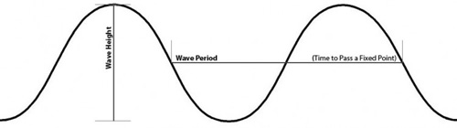
Wave Period
Wave or swell period is literally the time it takes for successive waves to pass the same point in seconds. Practically the peak period of a swell gives a great idea of how powerful the swell is and how likely it is to create good waves for surfing. Longer period swells also have a flatter profile in deep water, so create larger waves when entering shallow water to create surf.
4ft @ 10 seconds = 6ft breaking waves
4ft @ 20 seconds = 9ft breaking waves
Doubling the period gives about a 50% increase in the height of the breaking waves from the same sized swell.
Check out our guide to the ins and outs of different swell periods here.

What is primary swell and secondary swell?
Swell is divided into primary, secondary, tertiary etc. swell. This means that there might be several different storms in different places out the ocean producing swells in different directions that may all arrive to a particular location. A primary swell and a secondary swell moving in the same direction towards the same beach creates a bigger combined swell.
The realistic scenario is a number of swells each coming from different directions and with a range of swell heights and swell periods. For example: a primary swell from the south east of 2 ft and 12 seconds interval, with a secondary swell from the east of 1.3 ft and 9 seconds.
Some forecasts show only one combined swell estimate while others might show the top 3-5 swells.
The primary swell is the one in which is likely to produce the most impact in terms of waves to the beach.